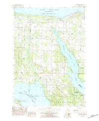
1983 Map of Bay Shore
USGS Topo · Published 1984About this map
Little Traverse Bay and Lake Charlevoix anchor this topographic survey of the coastal corridor between Bay Shore and the inland reaches of Walloon Lake. The landscape is characterized by a series of family-named cemeteries, including Dyer Cem and Undine Cem, alongside small rural settlements like Horton Bay. The era is evidenced by modern cultural markers such as a Drive-In Theater on Old Thirtyone Road and the industrial footprint of a large Quarry near the shore. Much of the southeastern portion of the map is dominated by the Mackinaw State Forest, where the terrain drops toward the community of Wildwood. Transportation is defined by a network of established local routes like Michigan Road and Stolt Road, which connect the shorelines across the county line between Charlevoix and Emmet counties.
Find a feature on this map
36 named features on this map. Tap any name to fly to it.
Don’t see what you’re looking for? This feature index may not catch every label — zoom into the map to look around manually.
Map Details
Editions of this 1983 Bay Shore Map
This is the sole edition of this map. No revisions or reprints were ever made.
Other maps of this area

1955 · Cheboygan
USGS Topo · 1:250,000

1958 · Cheboygan
USGS Topo · 1:250,000

1958 · Bayshore
USGS Topo · 1:62,500

1958 · Petoskey
USGS Topo · 1:62,500

1961 · Boyne Falls
USGS Topo · 1:62,500

1961 · Boyne City
USGS Topo · 1:62,500

1975 · Petoskey NW
USGS Topo · 1:24,000

1975 · Boyne City NW
USGS Topo · 1:24,000

1975 · Petoskey SW
USGS Topo · 1:24,000

1975 · Boyne City NE
USGS Topo · 1:24,000