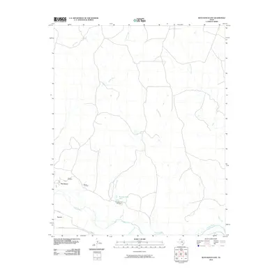
2010 Map of Boys Ranch East
USGS Topo · Published 2010About this map
The Canadian River cuts through the southern reaches of this landscape, marking a terrain defined by the deep drainage networks of the Texas Panhandle. Near the river's north bank, the community of Boys Ranch and the nearby Bivins Lit Ranch represent the enduring ranching character of Potter County. This area is steeped in regional history, anchored by the site of Tascosa and its associated Tascosa Cemetery, which reflect the early settlement patterns and cattle-driving heritage of the region. The map tracks the winding paths of numerous seasonal waterways, including Tascosa Creek, Lit Creek, and Pescado Creek, the latter of which is impounded by the Pescado Creek Lake Dam. Modern connectivity is maintained via Ranch Rd 1061 and Co Rd W, providing access across this arid landscape of creeks and draws.
Find a feature on this map
16 named features on this map. Tap any name to fly to it.
Don’t see what you’re looking for? This feature index may not catch every label — zoom into the map to look around manually.
Map Details
Editions of this 2010 Boys Ranch East Map
This is the sole edition of this map. No revisions or reprints were ever made.
Other maps of this area

1934 · Ady
USGS Topo · 1:62,500

1936 · Ady
USGS Topo · 1:62,500

1954 · Tucumcari
USGS Topo · 1:250,000

1958 · Tucumcari
USGS Topo · 1:250,000
1966 · Boden
USGS Topo · 1:24,000

1966 · Halfway Creek
USGS Topo · 1:24,000

1966 · Ady
USGS Topo · 1:24,000

1971 · Bivins Channing Ranch
USGS Topo · 1:24,000

1971 · Boys Ranch West
USGS Topo · 1:24,000
1971 · Little Indian Creek
USGS Topo · 1:24,000