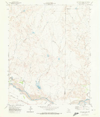
1971 Map of Boys Ranch East
USGS Topo · Published 1974About this map
Tascosa and Boys Ranch anchor this landscape along the north bank of the Canadian River in the Texas Panhandle. The area is defined by the complex drainage systems of Rica Creek, Tascosa Creek, and Pescado Creek cutting through the High Plains. Transport and infrastructure are vital to this ranching country, evidenced by the Ft Worth and Denver railroad line and a local Landing Strip. Cultural markers like the Tascosa Cem and the Bivins Lit Ranch speak to the local history of settlement and large-scale land use in Oldham County. Numerous gas wells and drill holes dot the terrain, showing the expansion of energy exploration into the traditional grazing lands. The presence of a Flowing Well and several springs highlights the critical importance of water management in this arid environment.
Find a feature on this map
19 named features on this map. Tap any name to fly to it.
Don’t see what you’re looking for? This feature index may not catch every label — zoom into the map to look around manually.
Map Details
Editions of this 1971 Boys Ranch East Map
This is the sole edition of this map. No revisions or reprints were ever made.
Other maps of this area

1934 · Ady
USGS Topo · 1:62,500

1936 · Ady
USGS Topo · 1:62,500

1954 · Tucumcari
USGS Topo · 1:250,000

1958 · Tucumcari
USGS Topo · 1:250,000
1966 · Boden
USGS Topo · 1:24,000

1966 · Halfway Creek
USGS Topo · 1:24,000

1966 · Ady
USGS Topo · 1:24,000

1971 · Bivins Channing Ranch
USGS Topo · 1:24,000

1971 · Boys Ranch West
USGS Topo · 1:24,000
1971 · Little Indian Creek
USGS Topo · 1:24,000