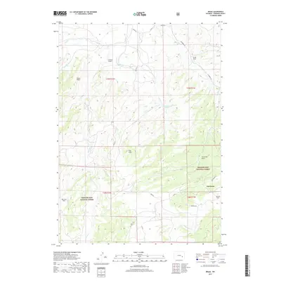
2017 Map of Braae
USGS Topo · Published 2017About this map
Medicine Bow National Forest encompasses much of this Converse County landscape, where the high-altitude terrain is defined by dramatic drainages like La Bonte Canyon and ridges such as Baldy Ridge. The rural settlement of Esterbrook sits on the eastern edge of the survey, connected by Esterbrook Rd to the surrounding ranching and forest lands. Significant family and local history markers are found here, including the Newell Cem and named clearings like Morrison Park and Ullman Park. Water management is represented by Indian Reservoir Number 1, which captures flow from Indian Cr. The map's network of unpaved roads, such as Braae Rd and Co Rd 5, provides access to these high country meadows and canyons, reflecting a landscape still used for its natural resources and remote homesteads.
Find a feature on this map
36 named features on this map. Tap any name to fly to it.
Don’t see what you’re looking for? This feature index may not catch every label — zoom into the map to look around manually.
Map Details
Editions of this 2017 Braae Map
This is the sole edition of this map. No revisions or reprints were ever made.
Other maps of this area

1943 · Esterbrook
USGS Topo · 1:62,500

1945 · Esterbrook
USGS Topo · 1:62,500

1949 · Poison Lake
USGS Topo · 1:24,000

1949 · Dilts Ranch
USGS Topo · 1:24,000

1950 · Poison Lake
USGS Topo · 1:24,000
1950 · Dilts Ranch
USGS Topo · 1:24,000

1954 · Torrington
USGS Topo · 1:250,000

1958 · Torrington
USGS Topo · 1:250,000
1964 · Maneater Creek
USGS Topo · 1:24,000

1964 · Saddleback Mountain
USGS Topo · 1:24,000