
1945 Map of Esterbrook
USGS Topo · Published 1945About this map
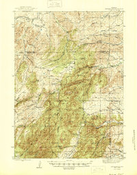
Esterbrook sits at the heart of this high-country landscape along the border of Converse and Albany counties. The area is defined by a dense network of family-operated ranching operations and remote mountain schools that served this isolated community in the mid-1940s. Notable ranching sites like the La Bonte Ranch, Macfarlane Ranch, and Atkinson Ranch are scattered among the foothills, while educational hubs such as Morton Sch and Hanks Sch highlight the dispersed settlement pattern. The terrain is dominated by prominent summits including Laramie Pk and Black Mtn, providing a backdrop for the numerous waterways like Horseshoe Creek and La Bonte Creek that drain the region. Local history enthusiasts can trace the Horseshoe Trail and identify former community centers like Binford or the gathering spaces of Harris Park and Ullman Park.
Find a feature on this map
62 named features on this map. Tap any name to fly to it.
Don’t see what you’re looking for? This feature index may not catch every label — zoom into the map to look around manually.
Map Details
Editions of this 1945 Esterbrook Map
2 editions found
Other maps of this area

1943 · Esterbrook
USGS Topo · 1:62,500

1949 · Poison Lake
USGS Topo · 1:24,000

1949 · Cedar Hill
USGS Topo · 1:24,000

1949 · Spring Creek
USGS Topo · 1:24,000

1949 · Dilts Ranch
USGS Topo · 1:24,000

1950 · Spring Creek
USGS Topo · 1:24,000

1950 · Poison Lake
USGS Topo · 1:24,000
1950 · Dilts Ranch
USGS Topo · 1:24,000

1950 · Cottonwood Falls
USGS Topo · 1:24,000
1951 · Cedar Hill
USGS Topo · 1:24,000