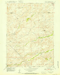
1951 Map of Cedar Hill
USGS Topo · Published 1951About this map
The high plains of the Converse Co Platte Co border are defined by a network of ranching outposts and drainage basins in this 1951 survey. Numerous family-named homesteads, including Fitzhugh Ranch, Stephenson Ranch, and Cundall Ranch, are positioned near vital water sources like Indian Creek and Elkhorn Creek. The landscape is largely defined by the prominent Cedar Hill and the winding course of North Elkhorn Creek. An industrial presence is marked by a prominent Pipe Line that cuts diagonally across the southwestern section of the quadrangle, traversing the terrain near Pollard Creek and Coffee Creek. Near the northern boundary, the settlement of Ammon serves as a small waypoint in this sparsely populated region of Wyoming, which was mapped as part of the Department of the Interior program for the development of the Missouri River Basin.
Find a feature on this map
20 named features on this map. Tap any name to fly to it.
Don’t see what you’re looking for? This feature index may not catch every label — zoom into the map to look around manually.
Map Details
Editions of this 1951 Cedar Hill Map
This is the sole edition of this map. No revisions or reprints were ever made.
Other maps of this area

1943 · Esterbrook
USGS Topo · 1:62,500

1945 · Esterbrook
USGS Topo · 1:62,500

1949 · Shawnee
USGS Topo · 1:24,000

1949 · Irvine
USGS Topo · 1:24,000

1949 · Cedar Hill
USGS Topo · 1:24,000

1949 · Spring Creek
USGS Topo · 1:24,000

1949 · Dilts Ranch
USGS Topo · 1:24,000

1949 · Orin
USGS Topo · 1:24,000

1950 · Glendo
USGS Topo · 1:24,000

1950 · Spring Creek
USGS Topo · 1:24,000