
1949 Map of Irvine
USGS Topo · Published 1960About this map
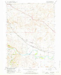
The North Platte River winds through the southern reaches of this landscape, its path tracked by a network of irrigation ditches and pumping stations essential for ranching in the high plains. Surveyed as part of the Missouri River Basin development program, the map captures the transition from river bottomlands to the rising terrain of Chalk. The Chicago and Northwestern railroad corridor dictates the settlement pattern, connecting the small rail stops of Irvine and Foster with the outlying Miller area. Aviation and navigation markers, including Beacon 11A and the Douglas Municipal Airport, stand out as modern additions to a landscape otherwise defined by traditional water rights and wind-driven wells. Numerous Windmills dot the sections between Sand Creek and La Bonte Creek, illustrating the dispersed nature of homesteading and livestock operations in Converse County during the late 1940s.
Find a feature on this map
24 named features on this map. Tap any name to fly to it.
Don’t see what you’re looking for? This feature index may not catch every label — zoom into the map to look around manually.
Map Details
Editions of this 1949 Irvine Map
2 editions found
Other maps of this area

1949 · Poison Lake
USGS Topo · 1:24,000

1949 · Cedar Hill
USGS Topo · 1:24,000

1949 · Douglas
USGS Topo · 1:24,000

1949 · Dilts Ranch
USGS Topo · 1:24,000

1949 · Chalk Buttes
USGS Topo · 1:24,000

1949 · Orin
USGS Topo · 1:24,000

1949 · Antelope Creek
USGS Topo · 1:24,000

1950 · Poison Lake
USGS Topo · 1:24,000

1950 · Douglas
USGS Topo · 1:24,000

1950 · Orin
USGS Topo · 1:24,000