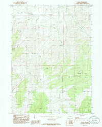
1985 Map of Braae
USGS Topo · Published 1985About this map
Braae is situated in a high-elevation landscape within the northern reaches of the Medicine Bow National Forest during the mid-1980s. This region is defined by a dense network of drainage systems, where La Bonte Creek carves through the prominent La Bonte Canyon in the west, while water features like Indian Reservoir and the seasonal Dry Lake dot the interior. The map reveals a transition from the named ridges and peaks like Baldy Ridge and Gray Rocks to the more open meadows of Morrison Park and Ullman Park. The naming of minor tributaries such as Ghost Creek, Hand Creek, and Horsethief Gulch suggests a landscape tied to early ranching and resource management, with topography that dictated the movement of livestock and people through the high country.
Find a feature on this map
23 named features on this map. Tap any name to fly to it.
Don’t see what you’re looking for? This feature index may not catch every label — zoom into the map to look around manually.
Map Details
Editions of this 1985 Braae Map
This is the sole edition of this map. No revisions or reprints were ever made.
Other maps of this area

1943 · Esterbrook
USGS Topo · 1:62,500

1945 · Esterbrook
USGS Topo · 1:62,500

1949 · Poison Lake
USGS Topo · 1:24,000

1949 · Dilts Ranch
USGS Topo · 1:24,000

1950 · Poison Lake
USGS Topo · 1:24,000
1950 · Dilts Ranch
USGS Topo · 1:24,000

1954 · Torrington
USGS Topo · 1:250,000

1958 · Torrington
USGS Topo · 1:250,000
1964 · Maneater Creek
USGS Topo · 1:24,000

1964 · Saddleback Mountain
USGS Topo · 1:24,000