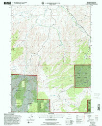
1992 Map of Braae
USGS Topo · Published 1996About this map
Braae is situated in a high-elevation landscape within the northern reaches of the Medicine Bow National Forest in Wyoming. This 1992 revision, based on surveys from the late 1970s and 1990, illustrates the intricate water network feeding into the Laramie Range foothills, including the drainage of La Bonte Creek and its many tributaries like Owl Creek, Bull Creek, and Softwater Creek. A small local Cem near the settlement of Braae and the nearby Indian Reservoir reflect the sparse but enduring human presence in this ranching and forest land. The terrain is marked by significant landmarks such as Baldy Ridge and Gray Rocks, while the Seventh Standard Parallel North cuts across the center of the sheet, providing a primary surveying reference point for Converse County. The map also delineates specialized areas like Ullman Park and the rugged La Bonte Canyon, essential for understanding local grazing and land use history.
Find a feature on this map
25 named features on this map. Tap any name to fly to it.
Don’t see what you’re looking for? This feature index may not catch every label — zoom into the map to look around manually.
Map Details
Editions of this 1992 Braae Map
This is the sole edition of this map. No revisions or reprints were ever made.
Other maps of this area

1943 · Esterbrook
USGS Topo · 1:62,500

1945 · Esterbrook
USGS Topo · 1:62,500

1949 · Poison Lake
USGS Topo · 1:24,000

1949 · Dilts Ranch
USGS Topo · 1:24,000

1950 · Poison Lake
USGS Topo · 1:24,000
1950 · Dilts Ranch
USGS Topo · 1:24,000

1954 · Torrington
USGS Topo · 1:250,000

1958 · Torrington
USGS Topo · 1:250,000
1964 · Maneater Creek
USGS Topo · 1:24,000

1964 · Saddleback Mountain
USGS Topo · 1:24,000