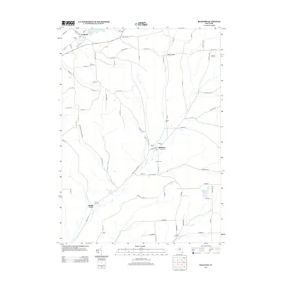
2013 Map of Bradford
USGS Topo · Published 2013About this map
Bradford and Monterey anchor this portion of Steuben County, where the landscape is defined by the winding paths of Meads Creek and Pine Creek. This 2013 survey reveals a rural territory rich in genealogical markers, featuring nearly a dozen named burial grounds including Schuyler Cemetery and the Old Sugar Hill Cemetery. The settlement pattern follows the valley floors and higher ridges, with agricultural holdings like Rose Hill Farm situated near the headwaters of local runs. To the north, Mill Pond and Mud Creek characterize the drainage around Bradford, while Cinnamon Lake sits tucked into the eastern hills. The map provides a clear view of the complex local road network, from the corridor of County Route 17 to the narrow hollows of Corbett Hollow and Coon Hollow Road, illustrating how historical land use remains tied to the local topography.
Find a feature on this map
84 named features on this map. Tap any name to fly to it.
Don’t see what you’re looking for? This feature index may not catch every label — zoom into the map to look around manually.
Map Details
Editions of this 2013 Bradford Map
This is the sole edition of this map. No revisions or reprints were ever made.
Other maps of this area

1895 · Elmira
USGS Topo · 1:62,500

1898 · Watkins Glen
USGS Topo · 1:62,500

1901 · Watkins
USGS Topo · 1:62,500

1903 · Hammondsport
USGS Topo · 1:62,500

1905 · Watkins Glen
USGS Topo · 1:125,000

1914 · Corning
USGS Topo · 1:62,500

1944 · Corning
USGS Topo · 1:62,500

1950 · Elmira
USGS Topo · 1:250,000
1950 · Reading Center
USGS Topo · 1:24,000
1953 · Wayne
USGS Topo · 1:24,000