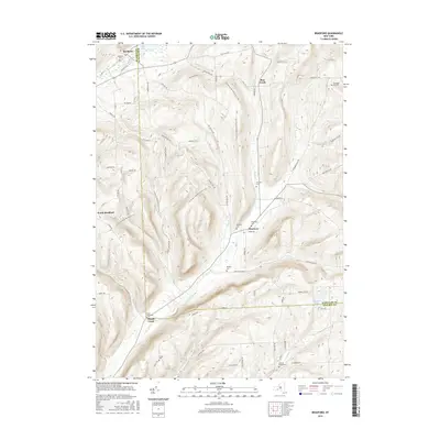
2016 Map of Bradford
USGS Topo · Published 2016About this map
The borderlands of Steuben and Schuyler counties are defined here by a series of narrow valleys and high ridges. Bradford and Monterey serve as the primary hubs of this landscape, linked by the winding course of Meads Creek and a network of rural routes like Co Rd 16 and Old State Rd. The area is notably dense with small, family-named burial grounds, such as Belmont Cemetery and Maltby Cemetery, which hint at the generations of settlers who farmed these hillsides.
Find a feature on this map
67 named features on this map. Tap any name to fly to it.
Don’t see what you’re looking for? This feature index may not catch every label — zoom into the map to look around manually.
Map Details
Editions of this 2016 Bradford Map
This is the sole edition of this map. No revisions or reprints were ever made.
Other maps of this area

1895 · Elmira
USGS Topo · 1:62,500

1898 · Watkins Glen
USGS Topo · 1:62,500

1901 · Watkins
USGS Topo · 1:62,500

1903 · Hammondsport
USGS Topo · 1:62,500

1905 · Watkins Glen
USGS Topo · 1:125,000

1914 · Corning
USGS Topo · 1:62,500

1944 · Corning
USGS Topo · 1:62,500

1950 · Elmira
USGS Topo · 1:250,000
1950 · Reading Center
USGS Topo · 1:24,000
1953 · Wayne
USGS Topo · 1:24,000