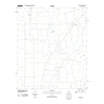
2010 Map of Bradshaw
USGS Topo · Published 2010About this map
Bradshaw and the smaller community of Drasco anchor this rural Taylor County landscape, where the terrain is defined by the prominent rise of Moro Mountain in the southeast. The settlement pattern follows a grid of county roads and farm-to-market routes like FM 1086 and FM 2405, linking isolated ranchlands and homesteads. Water management is central to the area's geography, evidenced by features such as Bluff Creek Dam and Downing Dam, which create small reservoirs like Downing Lake along the intermittent stream network. A complex drainage system including Mill Creek, Bulger Creek, and Salt Branch carves through the countryside, illustrating the hydrological challenges of this semi-arid region. The map preserves a moment of modern rural life before significant suburban encroachment, showing the persistent footprint of these small Texas crossroads as they appeared in the early 21st century.
Find a feature on this map
41 named features on this map. Tap any name to fly to it.
Don’t see what you’re looking for? This feature index may not catch every label — zoom into the map to look around manually.
Map Details
Editions of this 2010 Bradshaw Map
This is the sole edition of this map. No revisions or reprints were ever made.
Other maps of this area

1890 · Abilene
USGS Topo · 1:125,000

1891 · Hayrick
USGS Topo · 1:125,000

1892 · Abilene
USGS Topo · 1:125,000

1892 · Ballinger
USGS Topo · 1:125,000

1893 · Sweetwater
USGS Topo · 1:125,000

1894 · Hayrick
USGS Topo · 1:125,000

1954 · Brownwood
USGS Topo · 1:250,000

1954 · Big Spring
USGS Topo · 1:250,000

1954 · Abilene
USGS Topo · 1:250,000

1954 · San Angelo
USGS Topo · 1:250,000