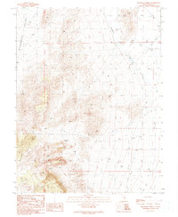
1990 Map of Bradshaw Spring
USGS Topo · Published 1990About this map
Duckwater Valley defines this arid landscape in central Nevada, where water sources dictated the sparse human presence of the late 20th century. The mountain slopes are marked by three named hydrologic features: Bradshaw Spring, Indian Spring, and Leeman Spring, which provide critical life-points in a high-desert environment. This 1988 field-check captures a working landscape of resource extraction and transit, evidenced by several Gravel Pits, exploratory Prospects, and a remote Water Well. The presence of Landing Strips and a single isolated Grave in the valley floor suggests the isolation of the area. A network of primitive 4 WD tracks and a man-made Ditch system alongside Duckwater Creek reveal how early inhabitants and surveyors navigated and modified this portion of Nye County to sustain livestock or mining operations.
Find a feature on this map
16 named features on this map. Tap any name to fly to it.
Don’t see what you’re looking for? This feature index may not catch every label — zoom into the map to look around manually.
Map Details
Editions of this 1990 Bradshaw Spring Map
This is the sole edition of this map. No revisions or reprints were ever made.
Other maps of this area

1956 · Lund
USGS Topo · 1:250,000

1960 · Lund
USGS Topo · 1:250,000

1964 · Blue Eagle Springs
USGS Topo · 1:62,500

1964 · Duckwater
USGS Topo · 1:62,500

1968 · Portuguese Mtn
USGS Topo · 1:62,500

1968 · Brown Summit
USGS Topo · 1:24,000
1968 · Sand Spring
USGS Topo · 1:24,000

1968 · Portuguese Mtn
USGS Topo · 1:24,000

1980 · Duckwater
USGS Topo · 1:100,000
1990 · Duckwater NE
USGS Topo · 1:24,000