
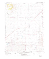
1964 Map of Blue Eagle Springs
USGS Topo · Published 1965About this map
Railroad Valley dominates this mid-1960s survey of central Nevada, where the sparse desert landscape is punctuated by vital water sources and emerging industrial activity. The Blue Eagle Ranch stands near its namesake Blue Eagle Springs, serving as a focal point for settlement in this arid basin. This era marks a significant transition in land use, as evidenced by the Oil Field and numerous drill holes that signal a push for resource extraction alongside traditional ranching.
Find a feature on this map
30 named features on this map. Tap any name to fly to it.
Don’t see what you’re looking for? This feature index may not catch every label — zoom into the map to look around manually.
Map Details
Editions of this 1964 Blue Eagle Springs Map
2 editions found
Other maps of this area

1956 · Lund
USGS Topo · 1:250,000

1957 · Currant Mtn
USGS Topo · 1:62,500

1960 · Lund
USGS Topo · 1:250,000

1964 · Duckwater
USGS Topo · 1:62,500

1964 · Currant
USGS Topo · 1:62,500

1964 · Currant Mtn
USGS Topo · 1:62,500

1964 · Troy Canyon
USGS Topo · 1:62,500

1964 · Forest Home
USGS Topo · 1:62,500

1968 · Portuguese Mtn
USGS Topo · 1:62,500

1968 · The Wall
USGS Topo · 1:62,500