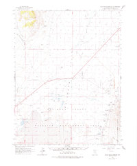
1964 Map of Blue Eagle Springs
USGS Topo · Published 1977About this map
Railroad Valley dominates this 1964 survey of Nye County, where a vast network of desert hydrology defines the landscape. The map centers on the Wildlife Management Area, highlighting the critical importance of water in this arid basin. Dozens of water sources are documented, from Blue Eagle Springs and Butterfield Springs to isolated features like Soda Spring, Cement Spring, and Kate Spring. The presence of The Big Well and several Flowing Wells indicates the reliance on subterranean water for both local wildlife and the Blue Eagle Ranch.
Find a feature on this map
40 named features on this map. Tap any name to fly to it.
Don’t see what you’re looking for? This feature index may not catch every label — zoom into the map to look around manually.
Map Details
Editions of this 1964 Blue Eagle Springs Map
2 editions found
Other maps of this area

1956 · Lund
USGS Topo · 1:250,000

1957 · Currant Mtn
USGS Topo · 1:62,500

1960 · Lund
USGS Topo · 1:250,000

1964 · Blue Eagle Springs
USGS Topo · 1:62,500

1964 · Duckwater
USGS Topo · 1:62,500

1964 · Currant
USGS Topo · 1:62,500

1964 · Currant Mtn
USGS Topo · 1:62,500

1964 · Troy Canyon
USGS Topo · 1:62,500

1964 · Forest Home
USGS Topo · 1:62,500

1968 · Portuguese Mtn
USGS Topo · 1:62,500