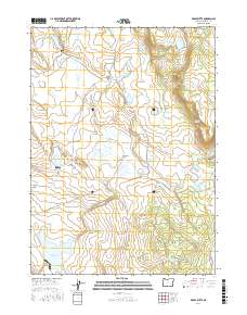
2017 Map of Brady Butte
USGS Topo · Published 2017About this map
Brady Butte rises as a prominent landmark over a high-desert landscape in Klamath County, characterized by an extensive network of water management features and seasonal drainages. The topography is defined by broad flats and volcanic rimrock, most notably Antelope Flat and the basaltic edge of Horse Camp Rim. Water resources are central to this area's geography, with numerous small impoundments such as Dog Hollow Reservoir, Jake Spring Reservoir, and Gerber Lower Division Reservoir providing vital collection points across the arid terrain. The map captures a high-plateau environment where natural features like The Bumpheads and Bear Valley Canyon contrast with the rectilinear grid of Bureau of Land Management routes. The drainage of Antelope Cr and the E Br Lost River connect these scattered reservoirs, illustrating the complex hydrology of the Oregon backcountry in the early 21st century.
Find a feature on this map
37 named features on this map. Tap any name to fly to it.
Don’t see what you’re looking for? This feature index may not catch every label — zoom into the map to look around manually.
Map Details
Editions of this 2017 Brady Butte Map
This is the sole edition of this map. No revisions or reprints were ever made.
Other maps of this area

1886 · Alturas
USGS Topo · 1:250,000

1886 · Modoc Lava Bed
USGS Topo · 1:250,000

1889 · Klamath
USGS Topo · 1:250,000

1892 · Modoc Lava-Bed
USGS Topo · 1:250,000

1892 · Alturas
USGS Topo · 1:250,000

1894 · Klamath
USGS Topo · 1:250,000

1951 · Clear Lake Reservoir
USGS Topo · 1:62,500

1954 · Alturas
USGS Topo · 1:250,000

1955 · Klamath Falls
USGS Topo · 1:250,000

1958 · Alturas
USGS Topo · 1:250,000