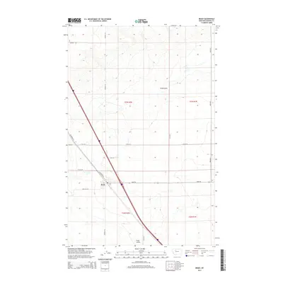
2014 Map of Brady
USGS Topo · Published 2014About this map
Brady serves as the primary settlement center within this Pondera County landscape, situated where the high plains meet the intricate drainage systems of Brady Coulee and Rocky Coulee. The map illustrates a strictly organized agricultural grid, defined by township lines like t27n r2w and t26n r1w, where rural life is facilitated by a network of named local roads. The transportation corridor of US Highway 91 S cuts diagonally across the western sections, providing the modern link between these isolated farmsteads and the broader region. Local family or landmark names are preserved in the road network, from Arod Lakes Rd to the descriptive Cattail Rd and Windmill Rd, reflecting a landscape dedicated to large-scale ranching and dryland farming during the early 21st century.
Find a feature on this map
22 named features on this map. Tap any name to fly to it.
Don’t see what you’re looking for? This feature index may not catch every label — zoom into the map to look around manually.
Map Details
Editions of this 2014 Brady Map
This is the sole edition of this map. No revisions or reprints were ever made.
Other maps of this area

1886 · Great Falls
USGS Topo · 1:250,000

1920 · Conrad
USGS Topo · 1:125,000

1950 · Dutton
USGS Topo · 1:62,500

1950 · Collins
USGS Topo · 1:62,500

1954 · Great Falls
USGS Topo · 1:250,000

1954 · Shelby
USGS Topo · 1:250,000

1957 · Great Falls
USGS Topo · 1:250,000

1958 · Shelby
USGS Topo · 1:250,000
1967 · Conrad
USGS Topo · 1:24,000

1967 · Brady
USGS Topo · 1:24,000