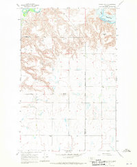
1967 Map of Conrad
USGS Topo · Published 1970About this map
The Whoop Up Trail cuts across this Pondera and Toole County landscape, marking a historic nineteenth-century freighting corridor that once connected Fort Benton to Fort Macleod. This 1967 field-checked survey reveals the rugged topography of the High Plains, where the Marias River and the northwestern reaches of the Tiber Reservoir carve through deeply eroded coulees. The terrain is defined by broad plateaus like Atkinson Flat and Tank Flat, which drop sharply into the river valley. Sparse rural settlement is evidenced by the presence of Union Sch and Higgins Sch, serving a community shaped by the Montana Principal Meridian. Land use is primarily agricultural, punctuated by a prominent Gravel Pit near Conrad Butte, illustrating the intersection of natural landforms and mid-century rural development.
Find a feature on this map
13 named features on this map. Tap any name to fly to it.
Don’t see what you’re looking for? This feature index may not catch every label — zoom into the map to look around manually.
Map Details
Editions of this 1967 Conrad Map
2 editions found
Other maps of this area

1920 · Dupuyer
USGS Topo · 1:125,000

1920 · Conrad
USGS Topo · 1:125,000

1934 · Valier
USGS Topo · 1:62,500

1937 · Valier
USGS Topo · 1:62,500

1938 · Gallup City
USGS Topo · 1:62,500

1942 · Gallup City
USGS Topo · 1:62,500

1954 · Shelby
USGS Topo · 1:250,000

1958 · Shelby
USGS Topo · 1:250,000

1960 · Cut Bank
USGS Topo · 1:250,000

1963 · Cut Bank
USGS Topo · 1:250,000