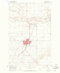
1967 Map of Conrad
USGS Topo · Published 1971About this map
The town of Conrad serves as the focal point of this Pondera County survey, situated at the intersection of agricultural land and the Great Northern railroad. The mapping reveals a well-established community infrastructure, from the local Hospital and High Sch to the industrial presence of Storage Bins near the tracks. To the north and south, the prairie is cut by the Dry Fork Marias River and Pondera Coulee, while irrigation needs are represented by an extensive Canal system.
Find a feature on this map
21 named features on this map. Tap any name to fly to it.
Don’t see what you’re looking for? This feature index may not catch every label — zoom into the map to look around manually.
Map Details
Editions of this 1967 Conrad Map
2 editions found
Other maps of this area

1920 · Dupuyer
USGS Topo · 1:125,000

1920 · Conrad
USGS Topo · 1:125,000

1934 · Valier
USGS Topo · 1:62,500

1937 · Valier
USGS Topo · 1:62,500

1938 · Gallup City
USGS Topo · 1:62,500

1942 · Gallup City
USGS Topo · 1:62,500

1954 · Shelby
USGS Topo · 1:250,000

1958 · Shelby
USGS Topo · 1:250,000

1960 · Cut Bank
USGS Topo · 1:250,000

1963 · Cut Bank
USGS Topo · 1:250,000