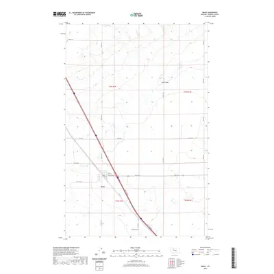
2020 Map of Brady
USGS Topo · Published 2020About this map
Brady serves as the primary hub for this Pondera County landscape, situated where the grid of rural roads meets the transportation corridor of Hwy 91 S and the Brady Frontage. The surrounding terrain is defined by the subtle drainage patterns of Brady Coulee to the north and Rocky Coulee to the south, which cut through the high plains. A rigid network of section roads like Arod Lakes Rd and Overpass Rd reveals the systematic agricultural layout of the region. This 2020 edition provides a clear record of the modern rural infrastructure, showing the small-town street plan of Brady centered on Central Ave E and 1st Ave N. The map reflects a classic Montana plains settlement pattern where life and commerce are closely tied to the highway and the expansive open spaces between these seasonal watercourses.
Find a feature on this map
22 named features on this map. Tap any name to fly to it.
Don’t see what you’re looking for? This feature index may not catch every label — zoom into the map to look around manually.
Map Details
Editions of this 2020 Brady Map
This is the sole edition of this map. No revisions or reprints were ever made.
Other maps of this area

1886 · Great Falls
USGS Topo · 1:250,000

1920 · Conrad
USGS Topo · 1:125,000

1950 · Dutton
USGS Topo · 1:62,500

1950 · Collins
USGS Topo · 1:62,500

1954 · Great Falls
USGS Topo · 1:250,000

1954 · Shelby
USGS Topo · 1:250,000

1957 · Great Falls
USGS Topo · 1:250,000

1958 · Shelby
USGS Topo · 1:250,000
1967 · Conrad
USGS Topo · 1:24,000

1967 · Brady
USGS Topo · 1:24,000