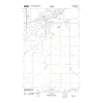
2010 Map of Brainerd
USGS Topo · Published 2010About this map
The Mississippi River winds through the heart of Brainerd, anchoring a landscape where civic infrastructure and natural waterways intersect. This 2010 survey captures the city's modern layout, from the Brainerd Post Office downtown to the Crow Wing County Fairgrounds in the southeast. Historical and community anchors are prominent, including the large Evergreen Cemetery and the northern reaches of the Cuyuna Range. The map reveals the area's transition from the dense urban grid of Brainerd to more expansive tracts like Meadow View Manor and Jackson Field. Numerous water bodies, such as Boom Lake, Rice Lake, and Buffalo Lake, emphasize the region's glacial geography, while landmarks like Lum Park Campground and the Rapids River Lodge and Waterpark highlight the importance of the river corridor for local recreation.
Find a feature on this map
55 named features on this map. Tap any name to fly to it.
Don’t see what you’re looking for? This feature index may not catch every label — zoom into the map to look around manually.
Map Details
Editions of this 2010 Brainerd Map
This is the sole edition of this map. No revisions or reprints were ever made.
Other maps of this area

1915 · Brainerd
USGS Topo · 1:62,500

1916 · Pillager
USGS Topo · 1:62,500

1918 · Brainerd
USGS Topo · 1:62,500

1919 · Pillager
USGS Topo · 1:62,500

1948 · Belle Prairie
USGS Topo · 1:62,500

1948 · Lastrup
USGS Topo · 1:62,500

1950 · Lastrup
USGS Topo · 1:62,500

1950 · Belle Prairie
USGS Topo · 1:62,500

1953 · Brainerd
USGS Topo · 1:250,000

1954 · Baxter
USGS Topo · 1:24,000
Featured Places
- Brainerd, MN
- Baxter, MN
- Westwood Mobile Home Park, Brainerd
- East Gate Mobile Home Park, Brainerd
- Meadow View Manor, Brainerd