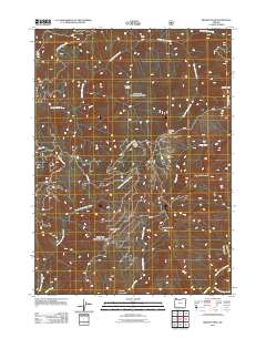
2011 Map of Brandy Peak
USGS Topo · Published 2011About this map
Brandy Peak and Squirrel Peak anchor this high-elevation landscape in Josephine County, where the terrain is defined by a complex network of drainages and upland openings. The survey illustrates a region dominated by the Indigo Creek watershed, including its primary tributaries like the North Fork Indigo Creek and East Fork Indigo Creek. These watercourses carve through the topography, separated by prominent landforms such as Burnt Ridge and Sugarloaf Mountain.
Find a feature on this map
19 named features on this map. Tap any name to fly to it.
Don’t see what you’re looking for? This feature index may not catch every label — zoom into the map to look around manually.
Map Details
Editions of this 2011 Brandy Peak Map
This is the sole edition of this map. No revisions or reprints were ever made.
Other maps of this area

1899 · Port Orford
USGS Topo · 1:125,000

1903 · Port Orford
USGS Topo · 1:125,000

1917 · Kerby
USGS Topo · 1:125,000

1918 · Kerby
USGS Topo · 1:125,000

1945 · Kerby
USGS Topo · 1:125,000

1954 · Coos Bay
USGS Topo · 1:250,000

1954 · Marial
USGS Topo · 1:62,500

1954 · Collier Butte
USGS Topo · 1:62,500

1954 · Agness
USGS Topo · 1:62,500

1954 · Pearsoll Peak
USGS Topo · 1:62,500