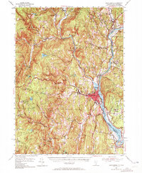
1954 Map of Brattleboro
USGS Topo · Published 1972About this map
Brattleboro serves as the focal point of this mid-century survey, situated where the West River joins the Connecticut River along the Vermont and New Hampshire border. The landscape is defined by the industrial and academic character of the mid-1950s, featuring both Windham College and Marlboro College, alongside the vital transportation corridor of the Central Vermont Railway. The terrain is marked by significant elevations like Wantastiquet Mountain and Black Mountain, which overlook a network of smaller villages such as Williamsville, Guilford Center, and West Chesterfield.
Find a feature on this map
120 named features on this map. Tap any name to fly to it.
Don’t see what you’re looking for? This feature index may not catch every label — zoom into the map to look around manually.
Map Details
Editions of this 1954 Brattleboro Map
4 editions found
Other maps of this area

1886 · Hawley
USGS Topo · 1:62,500

1887 · Warwick
USGS Topo · 1:62,500

1889 · Warwick
USGS Topo · 1:62,500

1889 · Wilmington
USGS Topo · 1:62,500

1890 · Hawley
USGS Topo · 1:62,500

1890 · Greenfield
USGS Topo · 1:62,500

1891 · Wilmington
USGS Topo · 1:62,500

1891 · Brattleboro
USGS Topo · 1:62,500

1893 · Brattleboro
USGS Topo · 1:62,500

1894 · Greenfield
USGS Topo · 1:62,500