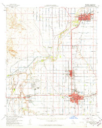
1957 Map of Brawley
USGS Topo · Published 1961About this map
The New River corridor in the mid-1950s reveals a landscape defined by the intricate engineering of the Imperial Valley's irrigation network. Between the primary hubs of El Centro, Imperial, and Brawley, the desert is partitioned by a dense grid of canals and drains, including the Westside Main Canal, Rose Drain, and Dolson Drain. This survey captures the region's industrial and military importance during the Cold War era, marked by the expansive Naval Auxiliary Air Station and a large Sugar Refinery north of Imperial.
Find a feature on this map
54 named features on this map. Tap any name to fly to it.
Don’t see what you’re looking for? This feature index may not catch every label — zoom into the map to look around manually.
Map Details
Editions of this 1957 Brawley Map
This is the sole edition of this map. No revisions or reprints were ever made.
Other maps of this area

1907 · Holtville
USGS Topo · 1:125,000

1915 · El Centro
USGS Topo · 1:125,000

1940 · Brawley
USGS Topo · 1:62,500

1940 · Kane Spring
USGS Topo · 1:62,500
1940 · Iris
USGS Topo · 1:62,500
1940 · Heber
USGS Topo · 1:62,500

1940 · Plaster City
USGS Topo · 1:62,500

1940 · Alamorio
USGS Topo · 1:62,500

1940 · Coyote Wells
USGS Topo · 1:62,500
1940 · Calexico
USGS Topo · 1:62,500