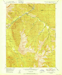
1950 Map of Bridal Veil Falls
USGS Topo · Published 1950About this map
The Provo River carves a deep path through this 1950 survey, providing a corridor for both nature and infrastructure. Small settlements such as Wildwood, Vivian Park, and Nunns are established along the riverbanks, alongside the tracks of the Denver & Rio Grande Western railroad. The most distinctive landmark is Bridal Veil Falls, a multi-tiered waterfall dropping from the high cliffs near the Alpine Scenic Highway.
Find a feature on this map
49 named features on this map. Tap any name to fly to it.
Don’t see what you’re looking for? This feature index may not catch every label — zoom into the map to look around manually.
Map Details
Editions of this 1950 Bridal Veil Falls Map
This is the sole edition of this map. No revisions or reprints were ever made.
Other maps of this area

1885 · Salt Lake
USGS Topo · 1:250,000

1907 · Strawberry Valley
USGS Topo · 1:125,000

1909 · Strawberry Valley
USGS Topo · 1:125,000

1948 · Timpanogos Cave
USGS Topo · 1:24,000

1948 · Orem
USGS Topo · 1:24,000

1948 · Orem
USGS Topo · 1:62,500

1948 · Springville
USGS Topo · 1:24,000

1948 · Aspen Grove
USGS Topo · 1:24,000

1948 · Provo
USGS Topo · 1:24,000

1948 · Bridal Veil Falls
USGS Topo · 1:24,000