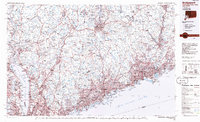
1986 Map of Bridgeport
USGS Topo · Published 1986About this map
The Hudson River corridor and the northern reaches of Long Island Sound anchor this mid-1980s look at the densely developed landscapes of Fairfield and Westchester counties. This era reveals a region defined by its critical infrastructure, including the Metro-North Railroad and the graceful curves of the Merritt Parkway. The map documents the extensive water management system serving the growing metropolitan area, with large impoundments like the New Croton Reservoir and Kensico Reservoir dominating the interior topography. Military history and presence are marked at the West Point U.S. Military Academy and Camp Smith Military Reservation along the highlands. Between the industrial river towns like Ossining and Tarrytown and the coastal centers of Stamford and Bridgeport, the map captures a suburban and exurban transition in full, punctuated by preserved lands such as Bear Mountain State Park and Sherwood Island State Park.
Find a feature on this map
134 named features on this map. Tap any name to fly to it.
Don’t see what you’re looking for? This feature index may not catch every label — zoom into the map to look around manually.
Map Details
Editions of this 1986 Bridgeport Map
3 editions found
Other maps of this area

1888 · Paterson
USGS Topo · 1:62,500

1889 · Derby
USGS Topo · 1:62,500

1891 · Ramapo
USGS Topo · 1:62,500

1891 · Harlem
USGS Topo · 1:62,500

1891 · Bridgeport
USGS Topo · 1:62,500

1891 · Derby
USGS Topo · 1:62,500

1892 · Stamford
USGS Topo · 1:62,500

1892 · West Point
USGS Topo · 1:62,500

1892 · New Haven
USGS Topo · 1:62,500

1892 · Danbury
USGS Topo · 1:62,500