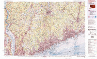
1986 Map of Bridgeport
USGS Topo · Published 1988About this map
The Hudson River and Long Island Sound anchor this mid-1980s topographic study of the tristate coastal corridor. Major urban centers from Bridgeport and Stamford to White Plains and Peekskill are shown amidst a complex network of reservoirs and parklands that support the region's dense population. This era reveals the mature transportation infrastructure of the Merritt Parkway and Connecticut Turnpike, while also detailing institutional landmarks such as Sing Sing Prison in Ossining and the West Point Military Academy. The map provides an intricate look at the hydraulic systems of the Croton Falls Reservoir and Kensico Reservoir, critical components of the area's water management. Notable educational and recreational sites, including Yale University and Ward Pound Ridge Reservation, are situated within the varied terrain that bridges the coastal lowlands and the inland highlands.
Find a feature on this map
202 named features on this map. Tap any name to fly to it.
Don’t see what you’re looking for? This feature index may not catch every label — zoom into the map to look around manually.
Map Details
Editions of this 1986 Bridgeport Map
3 editions found
Other maps of this area

1888 · Paterson
USGS Topo · 1:62,500

1889 · Derby
USGS Topo · 1:62,500

1891 · Ramapo
USGS Topo · 1:62,500

1891 · Harlem
USGS Topo · 1:62,500

1891 · Bridgeport
USGS Topo · 1:62,500

1891 · Derby
USGS Topo · 1:62,500

1892 · Stamford
USGS Topo · 1:62,500

1892 · West Point
USGS Topo · 1:62,500

1892 · New Haven
USGS Topo · 1:62,500

1892 · Danbury
USGS Topo · 1:62,500