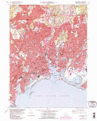
1970 Map of Bridgeport
USGS Topo · Published 1988About this map
The Pequonnock River cuts through the heart of the landscape, flowing into Bridgeport Harbor and defining the industrial and maritime layout of this coastal center. By the early 1970s, the urban footprint had expanded significantly, with updated infrastructure like the Connecticut Turnpike and Amtrak rail lines carving through established neighborhoods. This survey captures a dense network of local institutions, from the University of Bridgeport near Seaside Park to Sacred Heart University near the Fairfield line. Along the Long Island Sound, the transition from industrial waterfronts to natural features is evident at Fayerweather Island and the marshes of Great Meadows. The map provides a remarkable level of detail for genealogists, showing numerous religious and educational landmarks such as St Augustine Cathedral, Mount Grove Cemetery, and Bullard-Haven Sch, reflecting the community's mid-century civic growth.
Find a feature on this map
116 named features on this map. Tap any name to fly to it.
Don’t see what you’re looking for? This feature index may not catch every label — zoom into the map to look around manually.
Map Details
Editions of this 1970 Bridgeport Map
4 editions found
Other maps of this area

1889 · Derby
USGS Topo · 1:62,500

1891 · Bridgeport
USGS Topo · 1:62,500

1891 · Derby
USGS Topo · 1:62,500

1892 · Danbury
USGS Topo · 1:62,500

1892 · Norwalk
USGS Topo · 1:62,500

1893 · Bridgeport
USGS Topo · 1:62,500

1893 · Norwalk
USGS Topo · 1:62,500

1893 · Derby
USGS Topo · 1:62,500

1915 · Danbury
USGS Topo · 1:62,500

1920 · Bridgeport
USGS Topo · 1:62,500