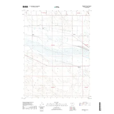
2017 Map of Bridgeport NW
USGS Topo · Published 2017About this map
The North Platte River corridor near Atkins is defined by an intricate network of irrigation systems developed to support agriculture in this arid region of Morrill County. Parallel water features like the Alliance Canal, Empire Canal, and Belmont Canal dominate the landscape, illustrating the engineering required to divert river water to the surrounding plains. The presence of the Oregon Trail Memorial Cem serves as a reminder of the area's significance as a historic western thoroughfare. Settlement patterns are concentrated at small junctions such as Mohler and DeGraw, while drainage features like Camp Clarke Drain and DeGraw Drain manage the hydraulic flow across the basin floor. The terrain transitions from the river's wetland margins to the structured grid of county roads, including Co RD 104 and Co RD 102, which connect the rural homesteads.
Find a feature on this map
28 named features on this map. Tap any name to fly to it.
Don’t see what you’re looking for? This feature index may not catch every label — zoom into the map to look around manually.
Map Details
Editions of this 2017 Bridgeport NW Map
This is the sole edition of this map. No revisions or reprints were ever made.
Other maps of this area

1898 · Camp Clarke
USGS Topo · 1:125,000

1954 · Scottsbluff
USGS Topo · 1:250,000

1958 · Scottsbluff
USGS Topo · 1:250,000

1965 · Bayard
USGS Topo · 1:24,000

1965 · Bridgeport NW
USGS Topo · 1:24,000

1965 · Angora SE
USGS Topo · 1:24,000

1965 · South Bayard
USGS Topo · 1:24,000

1965 · Courthouse Rock
USGS Topo · 1:24,000
1965 · Bridgeport
USGS Topo · 1:24,000
1965 · Angora
USGS Topo · 1:24,000