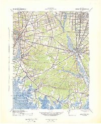
1942 Map of Bridgeton
USGS Topo · Published 1942About this map
The Cohansey River and Maurice River define this coastal New Jersey landscape, which was meticulously updated by the War Department just as the United States entered the Second World War. The region's industrial and agricultural character is evident in the dense rail networks of the Central Railroad of New Jersey and the West Jersey and Seashore RR, which linked centers like Bridgeton and Millville to the surrounding farms and coastal resources. To the south, the terrain transitions into the tidal marshes of The Glades and Buckshutem Swamp, where isolated outposts like Newport Landing and Tindells Landing provided water access to Delaware Bay.
Find a feature on this map
100 named features on this map. Tap any name to fly to it.
Don’t see what you’re looking for? This feature index may not catch every label — zoom into the map to look around manually.
Map Details
Editions of this 1942 Bridgeton Map
This is the sole edition of this map. No revisions or reprints were ever made.
Other maps of this area

1888 · Dennisville
USGS Topo · 1:62,500

1890 · Hammonton
USGS Topo · 1:62,500

1890 · Salem
USGS Topo · 1:62,500

1890 · Tuckahoe
USGS Topo · 1:62,500

1890 · Maurice Cove
USGS Topo · 1:62,500

1890 · Bay Side
USGS Topo · 1:62,500

1890 · Bridgeton
USGS Topo · 1:62,500

1890 · Glassboro
USGS Topo · 1:62,500

1891 · Maurice Cove
USGS Topo · 1:62,500

1893 · Tuckahoe
USGS Topo · 1:62,500