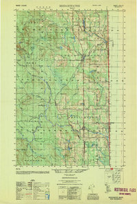
1953 Map of Bridgewater
USGS Topo · Published 1953About this map
The agricultural and timber lands of Aroostook County are defined here by the international border between Maine and New Brunswick. The Bangor and Aroostook railroad corridor serves as the primary spine for development, linking the established villages of Bridgewater and Monticello to smaller rural outposts like Robinsons and Snow Settlement. The landscape is a complex network of ridges such as Wellington Ridge and Coffins Ridge drained by the winding branches of the North Branch Meduxnekeag River. At the border, the U S Customs posts mark the crossings into Canada, highlighting the region's role as a gateway for international transit. Isolated rural schools like the Flagstaff Sch and West Road Sch suggest the community structure of these remote townships in the mid-20th century. Local landmarks like Number Nine Mountain and the water-logged basin of Advent Swamp illustrate the varied terrain of the Cox Patent and surrounding unorganized territories.
Find a feature on this map
69 named features on this map. Tap any name to fly to it.
Don’t see what you’re looking for? This feature index may not catch every label — zoom into the map to look around manually.
Map Details
Editions of this 1953 Bridgewater Map
This is the sole edition of this map. No revisions or reprints were ever made.
Other maps of this area

1934 · Bridgewater
USGS Topo · 1:48,000

1935 · Howe Brook
USGS Topo · 1:48,000

1935 · Presque Isle
USGS Topo · 1:62,500

1936 · Mars Hill
USGS Topo · 1:48,000

1937 · Smyrna Mills
USGS Topo · 1:62,500

1938 · Bridgewater
USGS Topo · 1:62,500
1938 · Houlton
USGS Topo · 1:62,500

1939 · Howe Brook
USGS Topo · 1:62,500
1940 · Mars Hill
USGS Topo · 1:62,500
1951 · Mars Hill
USGS Topo · 1:62,500