
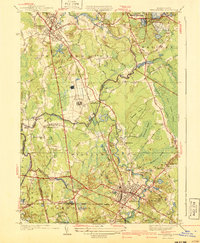
1940 Map of Bridgewater
USGS Topo · Published 1950About this map
The Taunton River and Nemasket River define the industrial and agricultural landscape of this Plymouth County region at the mid-century. Centered on Bridgewater and Middleboro, the map reveals a community deeply integrated with the wetlands and waterways of southeastern Massachusetts. Extensive Cranberry Bogs, including the Washburn Bogs, Richmond Bog, and Atwood Bogs, highlight the importance of the regional cranberry industry.
Find a feature on this map
63 named features on this map. Tap any name to fly to it.
Don’t see what you’re looking for? This feature index may not catch every label — zoom into the map to look around manually.
Map Details
Editions of this 1940 Bridgewater Map
3 editions found
Other maps of this area

1885 · Abington
USGS Topo · 1:62,500

1885 · Middleboro
USGS Topo · 1:62,500

1885 · Taunton
USGS Topo · 1:62,500

1886 · Dedham
USGS Topo · 1:62,500

1888 · Taunton
USGS Topo · 1:62,500

1888 · Middleboro
USGS Topo · 1:62,500

1888 · Abington
USGS Topo · 1:62,500

1893 · Abington
USGS Topo · 1:62,500

1893 · Taunton
USGS Topo · 1:62,500

1893 · Middleboro
USGS Topo · 1:62,500