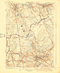
1940 Map of Bridgewater
USGS Topo · Published 1940About this map
The Taunton River and its major tributary, the Nemasket River, define the agricultural and institutional character of this Plymouth County landscape. At the center of the sheet, the massive State Farm complex and the Lakeville State Sanitorium indicate the region's historical role in hosting large-scale state facilities. The convergence of the New York New Haven and Hartford railroad lines in Middleboro underscores the town's importance as a regional transportation hub, while the surrounding area is dominated by specialized horticulture, visible in the extensive networks of Cranberry Bogs, Osburn Bog, and Fish Bogs.
Find a feature on this map
61 named features on this map. Tap any name to fly to it.
Don’t see what you’re looking for? This feature index may not catch every label — zoom into the map to look around manually.
Map Details
Editions of this 1940 Bridgewater Map
3 editions found
Other maps of this area

1885 · Abington
USGS Topo · 1:62,500

1885 · Middleboro
USGS Topo · 1:62,500

1885 · Taunton
USGS Topo · 1:62,500

1886 · Dedham
USGS Topo · 1:62,500

1888 · Taunton
USGS Topo · 1:62,500

1888 · Middleboro
USGS Topo · 1:62,500

1888 · Abington
USGS Topo · 1:62,500

1893 · Abington
USGS Topo · 1:62,500

1893 · Taunton
USGS Topo · 1:62,500

1893 · Middleboro
USGS Topo · 1:62,500