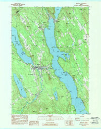
1983 Map of Bridgton
USGS Topo · Published 1984About this map
Long Lake and Highland Lake dominate this landscape, illustrating the recreational and residential character of the lakes region during the early 1980s. The village of Bridgton serves as the central hub, situated between these major water bodies and supported by institutions like the North Cumberland Memorial Hosp. The surrounding terrain, defined by features such as Upper Ridge and Lower Ridge, is dotted with family-named cemeteries including Maple Ridge Cem and Finnish Cem, providing significant data for genealogical research. A dense concentration of summer camps like Camp Ticiwa, Camp Wildwoods, and Camp Beaumont along the shorelines reflects the area's long-standing tradition as a seasonal destination. Evidence of local infrastructure includes the Maple Ridge Airport and a Drive-in Theater, highlighting the mid-century developments that persisted into this era of surveying.
Find a feature on this map
85 named features on this map. Tap any name to fly to it.
Don’t see what you’re looking for? This feature index may not catch every label — zoom into the map to look around manually.
Map Details
Editions of this 1983 Bridgton Map
This is the sole edition of this map. No revisions or reprints were ever made.
Other maps of this area

1896 · Norway
USGS Topo · 1:62,500

1896 · Sebago
USGS Topo · 1:62,500

1909 · Fryeburg
USGS Topo · 1:62,500

1910 · Kezar Falls
USGS Topo · 1:48,000

1911 · Fryeburg
USGS Topo · 1:62,500

1911 · Kezar Falls
USGS Topo · 1:62,500

1941 · Fryeburg
USGS Topo · 1:62,500

1942 · Sebago Lake
USGS Topo · 1:62,500

1943 · Sebago Lake
USGS Topo · 1:62,500

1946 · Norway
USGS Topo · 1:62,500