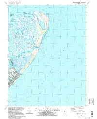
1994 Map of Brigantine Inlet
USGS Topo · Published 1998About this map
The salt marshes and coastal barrier islands of New Jersey are meticulously detailed in this survey of the northern reaches of Brigantine. The landscape is dominated by the Edwin B Forsythe National Wildlife Refuge, which spans a complex network of coastal channels including Salt Island Thorofare, Great Thorofare, and Simkins Thorofare. These waterways create a labyrinthine geography of islands such as Dog Island and Pullen Island before meeting the open Atlantic Ocean at Brigantine Inlet.
Find a feature on this map
34 named features on this map. Tap any name to fly to it.
Don’t see what you’re looking for? This feature index may not catch every label — zoom into the map to look around manually.
Map Details
Editions of this 1994 Brigantine Inlet Map
This is the sole edition of this map. No revisions or reprints were ever made.
Other maps of this area

1887 · Atlantic City
USGS Topo · 1:62,500

1888 · Little Egg Harbor
USGS Topo · 1:62,500

1888 · Long Beach
USGS Topo · 1:62,500

1893 · Little Egg Harbor
USGS Topo · 1:62,500

1893 · Long Beach
USGS Topo · 1:62,500

1894 · Atlantic City
USGS Topo · 1:62,500

1919 · Long Beach
USGS Topo · 1:62,500

1920 · Little Egg Harbor
USGS Topo · 1:62,500

1940 · Atlantic City
USGS Topo · 1:62,500
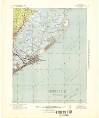
1941 · Atlantic City
USGS Topo · 1:62,500
Featured Places
- Galloway Township, NJ
- Little Egg Harbor Township, NJ
- Brigantine, NJ
- Ocean County, NJ
- Atlantic County, NJ