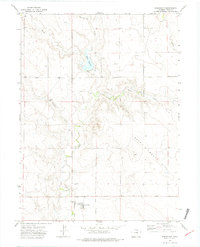
1972 Map of Briggsdale
USGS Topo · Published 1975About this map
Briggsdale anchors this northern Colorado landscape, established as a central point for the surrounding dryland farming community in Weld County. The 1972 topography reveals a mix of agricultural infrastructure and natural drainage patterns, with the townsite featuring concentrated Storage Bins and the nearby Briggsdale Cem. The area is defined by its water management, seen in the Heart Reservoir and its Spillway, along with smaller catchments like Murphy Res. These water sources are fed by an intricate network of seasonal flows including Little Crow Creek, Willow Creek, and Howard Creek. To the east, the terrain rises into the distinctive Seven Cross Hills, while the Crow Valley Park provides a managed green space near the central settlement. The map documents the persistent agricultural footprint of the region, where numerous Well locations and a solitary Oil Well reflect the area's reliance on both surface and subsurface resources.
Find a feature on this map
14 named features on this map. Tap any name to fly to it.
Don’t see what you’re looking for? This feature index may not catch every label — zoom into the map to look around manually.
Map Details
Editions of this 1972 Briggsdale Map
3 editions found
Other maps of this area

1954 · Greeley
USGS Topo · 1:250,000

1957 · Greeley
USGS Topo · 1:250,000

1958 · Greeley
USGS Topo · 1:250,000

1961 · Greeley
USGS Topo · 1:250,000

1964 · Greeley
USGS Topo · 1:250,000

1965 · Greeley
USGS Topo · 1:250,000

1972 · Dutch Girl Lake
USGS Topo · 1:24,000

1972 · Briggsdale
USGS Topo · 1:24,000

1972 · Keota NW
USGS Topo · 1:24,000
1972 · Reno Reservoir
USGS Topo · 1:24,000