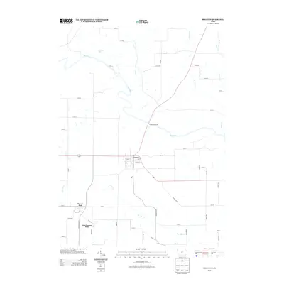
2013 Map of Brighton
USGS Topo · Published 2013About this map
The Skunk River carves a winding path through this corner of southeast Iowa, defining the rural character of Washington County. The town of Brighton serves as a central hub, situated where regional routes intersect near the river's bend. To the southwest, the adjacent settlements of Pleasant Plain and East Pleasant Plain reflect the area's agricultural heritage and grid-based development. Public recreation is anchored by the Brighton Boat Access, providing a critical entry point to the river system. The landscape is further defined by a series of drainages, including Indian Cr, Burr Oak Cr, and Walnut Cr, which feed into the primary river valley. Notable landmarks like Wallrich Lake dot the northern territory, illustrating the varied water features that have influenced local land use and farm placement for generations.
Find a feature on this map
61 named features on this map. Tap any name to fly to it.
Don’t see what you’re looking for? This feature index may not catch every label — zoom into the map to look around manually.
Map Details
Editions of this 2013 Brighton Map
This is the sole edition of this map. No revisions or reprints were ever made.
Other maps of this area

1958 · Davenport
USGS Topo · 1:250,000

1961 · Davenport
USGS Topo · 1:250,000

1962 · Davenport
USGS Topo · 1:250,000

1969 · Washington
USGS Topo · 1:24,000
1973 · Keota
USGS Topo · 1:24,000

1973 · West Chester
USGS Topo · 1:24,000
1980 · Fairfield North
USGS Topo · 1:24,000
1980 · Richland
USGS Topo · 1:24,000

1980 · Brighton
USGS Topo · 1:24,000

1980 · Trenton
USGS Topo · 1:24,000