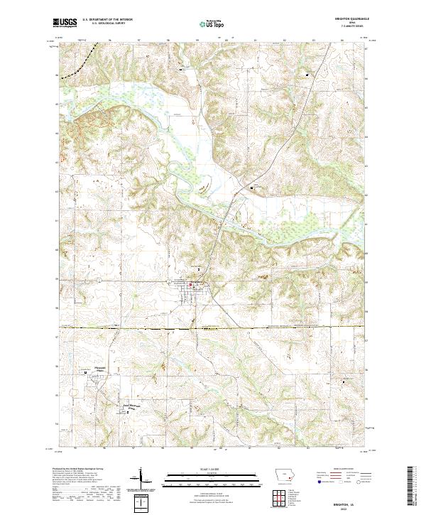
2022 Map of Brighton
USGS Topo · Published 2022About this map
The Brighton town site serves as the focal point of this rural landscape, situated just north of the county line between Washington County and Jefferson County. The Skunk River carves a winding path through the center of the sheet, joined by tributaries such as Indian Creek and Burr Oak Creek. This area of Iowa is characterized by its organized grid of secondary roads, including Ginkgo Avenue and Ivy Avenue, which connect scattered agricultural lands and several family-named cemeteries. For genealogists, the map is particularly useful for locating burial grounds like Hillcrest Cemetery on the edge of town, Sandy Hook Cemetery near the river, and Saint Josephs Cemetery to the south. Recreational corridors such as the Brinton Timber Trails Trail and Wallrich Lake illustrate the intersection of modern land use with these long-standing farming communities.
Find a feature on this map
66 named features on this map. Tap any name to fly to it.
Don’t see what you’re looking for? This feature index may not catch every label — zoom into the map to look around manually.
Map Details
Editions of this 2022 Brighton Map
This is the sole edition of this map. No revisions or reprints were ever made.
Other maps of this area

1958 · Davenport
USGS Topo · 1:250,000

1961 · Davenport
USGS Topo · 1:250,000

1962 · Davenport
USGS Topo · 1:250,000

1969 · Washington
USGS Topo · 1:24,000
1973 · Keota
USGS Topo · 1:24,000

1973 · West Chester
USGS Topo · 1:24,000
1980 · Fairfield North
USGS Topo · 1:24,000
1980 · Richland
USGS Topo · 1:24,000

1980 · Brighton
USGS Topo · 1:24,000

1980 · Trenton
USGS Topo · 1:24,000