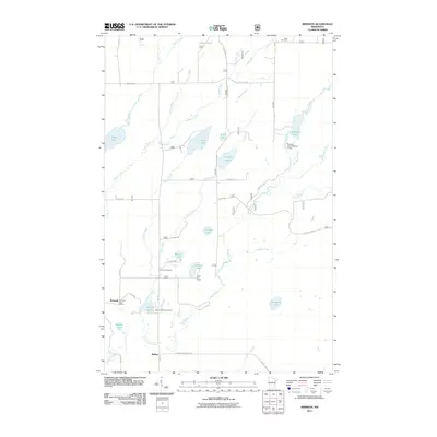
2011 Map of Brimson
USGS Topo · Published 2011About this map
Brimson serves as a small social center in this northern landscape, situated near the intersection of HWY 44 and Co Rd 314. This 2011 survey depicts the rural character of Saint Louis County, where the Brimson Post Office and nearby Brimson Cemetery anchor the community history. The Cloquet River snakes through the southern portion of the quadrangle, which is otherwise dominated by a complex network of glacial water bodies like Indian Lake, Wilson Lake, and Breda Lake. Local family and place names are preserved through road labels such as Hiironen Rd, Elo Rd, and Twp Rd 6205. To the north, Toimi Cemetery marks the edge of the settled area near Brimson Toimi Rd. This map is particularly useful for identifying the specific locations of landmarks like the Camp FE House and infrastructure including the Murphy Lake Number 1 Dam.
Find a feature on this map
50 named features on this map. Tap any name to fly to it.
Don’t see what you’re looking for? This feature index may not catch every label — zoom into the map to look around manually.
Map Details
Editions of this 2011 Brimson Map
This is the sole edition of this map. No revisions or reprints were ever made.
Other maps of this area

1953 · Whyte
USGS Topo · 1:62,500

1954 · Two Harbors
USGS Topo · 1:250,000

1956 · Pequaywan Lake
USGS Topo · 1:24,000

1956 · King Lake
USGS Topo · 1:24,000

1957 · Two Harbors
USGS Topo · 1:250,000

1957 · Two Harbors
USGS Topo · 1:62,500

1957 · Brimson
USGS Topo · 1:62,500

1958 · Two Harbors
USGS Topo · 1:250,000

1964 · Two Harbors
USGS Topo · 1:250,000
1976 · Brimson SW
USGS Topo · 1:24,000