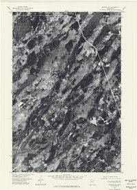
1976 Map of Brimson SW
USGS Topo · Published 1979About this map
The West Branch Cloquet River meanders through a dense, lake-studded landscape in this 1976 orthophotoquad, showing the intricate hydrology of St. Louis County. This aerial perspective captures the region before more modern development, emphasizing the natural state of water bodies like Wolf Lake and Bassett Lake. The orthophoto format provides a clear view of the timber and wetland patterns that characterize this portion of northeastern Minnesota. Unlike a traditional topographic map, these photographic images help researchers identify the specific texture of the vegetation and the untouched shorelines of the era. The lack of named settlements or major infrastructure highlights the isolated, wilderness character of the area during the mid-1970s.
Find a feature on this map
3 named features on this map. Tap any name to fly to it.
Don’t see what you’re looking for? This feature index may not catch every label — zoom into the map to look around manually.
Map Details
Editions of this 1976 Brimson SW Map
This is the sole edition of this map. No revisions or reprints were ever made.
Other maps of this area

1954 · Two Harbors
USGS Topo · 1:250,000

1954 · Hibbing
USGS Topo · 1:250,000

1956 · Pequaywan Lake
USGS Topo · 1:24,000

1956 · King Lake
USGS Topo · 1:24,000

1957 · Two Harbors
USGS Topo · 1:250,000

1957 · Hibbing
USGS Topo · 1:250,000

1957 · Brimson
USGS Topo · 1:62,500

1957 · Markham
USGS Topo · 1:62,500
1957 · Boulder Lake Reservoir NE
USGS Topo · 1:24,000

1958 · Hibbing
USGS Topo · 1:250,000