
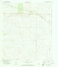
1971 Map of Brinson Ranch
USGS Topo · Published 1973About this map
Monument Draw cuts a distinct path through this West Texas landscape, winding across the high plains of the Llano Estacado. The area is defined by the industrial and ranching activity characteristic of the Permian Basin, where cattle grazing at Brinson Ranch coexists with extensive energy infrastructure. A network of pipelines and numerous drill holes crisscross the terrain, marking the intensification of oil and gas exploration in the early 1970s. The county line separating Gaines and Andrews County bisects the southern portion of the quadrangle, passing through a relatively flat expanse marked only by occasional gravel pits and isolated wells. This survey provides a precise view of a working landscape where traditional ranching meets the technological footprint of the Texas petroleum industry.
Find a feature on this map
7 named features on this map. Tap any name to fly to it.
Don’t see what you’re looking for? This feature index may not catch every label — zoom into the map to look around manually.
Map Details
Editions of this 1971 Brinson Ranch Map
This is the sole edition of this map. No revisions or reprints were ever made.
Other maps of this area

1954 · Hobbs
USGS Topo · 1:250,000

1958 · Hobbs
USGS Topo · 1:250,000

1969 · Hobbs East
USGS Topo · 1:24,000

1969 · Hobbs SE
USGS Topo · 1:24,000

1969 · Eunice NE
USGS Topo · 1:24,000

1971 · Paynes Corner
USGS Topo · 1:24,000

1971 · Paynes Corner SE
USGS Topo · 1:24,000

1971 · Frankel City
USGS Topo · 1:24,000

1971 · Jumbo Hill
USGS Topo · 1:24,000
1971 · Paynes Corner NW
USGS Topo · 1:24,000