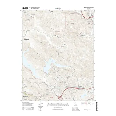
2015 Map of Briones Valley
USGS Topo · Published 2015About this map
Briones Reservoir and San Pablo Reservoir dominate this 2015 study of the East Bay hills, where protected open space and suburban expansion meet. The map reveals the intricate infrastructure required for this Mediterranean landscape, including the Mokelumne Aqueduct and the Lafayette Water Tunnel. In the northeast corner, the legacy of American conservation is anchored at the John Muir National Historic Site near Martinez, while the southwest corner transitions into the urban edge of Berkeley and Orinda. The terrain is characterized by a series of northwest-trending ridges like Pinole Ridge and Oursan Ridge, punctuated by small settlements and academic outposts like John F Kennedy Univ. Smaller, likely older place names such as Christie and Glen Frazer hint at early rail or ranching points along the canyon bottoms that predate the modern residential corridors of Lafayette.
Find a feature on this map
162 named features on this map. Tap any name to fly to it.
Don’t see what you’re looking for? This feature index may not catch every label — zoom into the map to look around manually.
Map Details
Editions of this 2015 Briones Valley Map
This is the sole edition of this map. No revisions or reprints were ever made.
Other maps of this area

1895 · San Francisco
USGS Topo · 1:62,500

1896 · Carquinez Strait
USGS Topo · 1:62,500

1897 · Concord
USGS Topo · 1:62,500

1898 · Karquines
USGS Topo · 1:62,500

1899 · San Francisco
USGS Topo · 1:62,500

1901 · Karquines
USGS Topo · 1:62,500

1902 · Napa
USGS Topo · 1:125,000

1915 · Concord
USGS Topo · 1:62,500

1915 · San Francisco
USGS Topo · 1:62,500

1916 · Mare Island
USGS Topo · 1:62,500