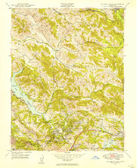
1947 Map of Briones Valley
USGS Topo · Published 1954About this map
The San Pablo Reservoir dominates the western portion of this 1940s landscape, serving as a critical water node with its Intake Tower and nearby Filtration Plant. This era shows the East Bay transitioning from ranching lands toward more concentrated residential pockets in Orinda Village and Lafayette. The rugged interior is defined by massive land grants and ridge systems like La Boca de la Cañada del Pinole and the Briones Hills, where traditional rural life is still evidenced by the Briones Valley Sch.
Find a feature on this map
45 named features on this map. Tap any name to fly to it.
Don’t see what you’re looking for? This feature index may not catch every label — zoom into the map to look around manually.
Map Details
Editions of this 1947 Briones Valley Map
This is the sole edition of this map. No revisions or reprints were ever made.
Other maps of this area

1895 · San Francisco
USGS Topo · 1:62,500

1896 · Carquinez Strait
USGS Topo · 1:62,500

1897 · Concord
USGS Topo · 1:62,500

1898 · Karquines
USGS Topo · 1:62,500

1899 · San Francisco
USGS Topo · 1:62,500

1901 · Karquines
USGS Topo · 1:62,500

1902 · Napa
USGS Topo · 1:125,000

1915 · Concord
USGS Topo · 1:62,500

1915 · San Francisco
USGS Topo · 1:62,500

1916 · Mare Island
USGS Topo · 1:62,500