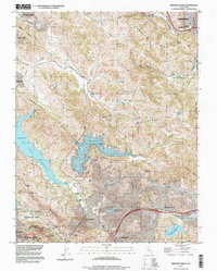
1995 Map of Briones Valley
USGS Topo · Published 1999About this map
John Muir National Historic Site and the historic settlement of Muir anchor the northeastern corner of this study, where the Southern Pacific tracks navigate the gap near Martinez. The landscape is defined by the high ridges of the East Bay, including Pinole Ridge and Sobrante Ridge, which frame the critical water infrastructure of the Briones Reservoir and San Pablo Reservoir. Large tracts of protected land, such as Charles Lee Tilden Regional Park and Briones Regional Park, preserve the topography between the growing residential centers of Orinda and Lafayette. The map illustrates the complex intersection of early Spanish land grants, including Rancho El Sobrante and Rancho Acalanes, with the mid-century suburban expansion of the 1950s. Infrastructure like the Mokelumne Aqueduct underscores the region's role in the California water system.
Find a feature on this map
76 named features on this map. Tap any name to fly to it.
Don’t see what you’re looking for? This feature index may not catch every label — zoom into the map to look around manually.
Map Details
Editions of this 1995 Briones Valley Map
This is the sole edition of this map. No revisions or reprints were ever made.
Other maps of this area

1895 · San Francisco
USGS Topo · 1:62,500

1896 · Carquinez Strait
USGS Topo · 1:62,500

1897 · Concord
USGS Topo · 1:62,500

1898 · Karquines
USGS Topo · 1:62,500

1899 · San Francisco
USGS Topo · 1:62,500

1901 · Karquines
USGS Topo · 1:62,500

1902 · Napa
USGS Topo · 1:125,000

1915 · Concord
USGS Topo · 1:62,500

1915 · San Francisco
USGS Topo · 1:62,500

1916 · Mare Island
USGS Topo · 1:62,500