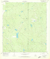
1969 Map of Briscoe Ranch
USGS Topo · Published 1972About this map
Briscoe Ranch (Hdqrs) serves as the central hub of this South Texas landscape, situated near the boundary between La Salle County and McMullen County. The terrain is defined by a sophisticated system of earthen stock tanks, essential for ranching operations in this arid environment. Significant water features such as Big Alamo Tank, Little Alamo Tank, and Tanque Las Tres Puertas are scattered throughout the brush country, connected by ephemeral drainages like Elm Creek and Guadalupe Creek.
Find a feature on this map
35 named features on this map. Tap any name to fly to it.
Don’t see what you’re looking for? This feature index may not catch every label — zoom into the map to look around manually.
Map Details
Editions of this 1969 Briscoe Ranch Map
This is the sole edition of this map. No revisions or reprints were ever made.
Other maps of this area

1930 · Tilden
USGS Topo · 1:62,500

1937 · Loma Alta
USGS Topo · 1:62,500

1942 · Fowlerton
USGS Topo · 1:62,500

1942 · Tilden
USGS Topo · 1:62,500

1953 · Crystal City
USGS Topo · 1:250,000

1955 · Crystal City
USGS Topo · 1:250,000

1956 · Piedra Creek
USGS Topo · 1:62,500

1956 · Fowlerton
USGS Topo · 1:62,500

1961 · Crystal City
USGS Topo · 1:250,000

1968 · Crystal City
USGS Topo · 1:250,000