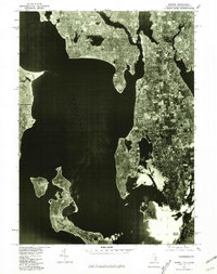
1975 Map of Bristol
USGS Topo · Published 1981About this map
Narragansett Bay defines this orthophotoquad, which uses rectified 1975 aerial photography to document the coastal layout of eastern Rhode Island. The image-based format provides a clear view of the mid-1970s land use, capturing the dense residential and commercial patterns of Bristol and Warren as they appeared before late-twentieth-century development. The intersection of the Barrington River and Palmer River in the north creates a complex tidal landscape, while the northern tip of Prudence Island sits isolated in the lower half of the frame.
Find a feature on this map
10 named features on this map. Tap any name to fly to it.
Don’t see what you’re looking for? This feature index may not catch every label — zoom into the map to look around manually.
Map Details
Editions of this 1975 Bristol Map
This is the sole edition of this map. No revisions or reprints were ever made.
Other maps of this area

1885 · Taunton
USGS Topo · 1:62,500

1887 · Providence
USGS Topo · 1:62,500

1888 · Fall River
USGS Topo · 1:62,500

1888 · Taunton
USGS Topo · 1:62,500

1889 · Providence
USGS Topo · 1:62,500

1890 · Narragansett Bay
USGS Topo · 1:62,500

1892 · Narragansett Bay
USGS Topo · 1:62,500

1893 · Taunton
USGS Topo · 1:62,500

1893 · Fall River
USGS Topo · 1:62,500

1894 · Providence
USGS Topo · 1:62,500