
1973 Map of Bristol East
USGS Topo · Published 1976About this map
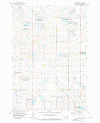
The Chicago Milwaukee St Paul and Pacific railroad forms the primary corridor through this Day County landscape, connecting the small grain-belt settlements of Bristol and Holmquist. Further south, the town of Butler sits at the edge of a vast wetland basin, reflecting the characteristic prairie pothole topography of eastern South Dakota. The survey meticulously documents the intersection of agriculture and conservation, noting several Gravel Pits alongside protected lands such as the Holmquist Slough State Public Shooting Area and the National Waterfowl Production Area. Local history is preserved in the location of several rural burial grounds, including Prairie Mound Cem and Ebenezer Cem, while significant water bodies like Bitter Lake and Holmquist Slough dominate the low-lying terrain of Valley and Butler townships.
Find a feature on this map
20 named features on this map. Tap any name to fly to it.
Don’t see what you’re looking for? This feature index may not catch every label — zoom into the map to look around manually.
Map Details
Editions of this 1973 Bristol East Map
This is the sole edition of this map. No revisions or reprints were ever made.
Other maps of this area

1953 · Milbank
USGS Topo · 1:250,000

1958 · Milbank
USGS Topo · 1:250,000

1958 · Pierpont
USGS Topo · 1:24,000

1973 · Lily
USGS Topo · 1:24,000

1973 · Lynn Lake
USGS Topo · 1:24,000

1973 · Webster
USGS Topo · 1:24,000

1973 · Bristol West
USGS Topo · 1:24,000

1973 · Swan Lake
USGS Topo · 1:24,000

1973 · Lone Tree Lake
USGS Topo · 1:24,000
1973 · Webster NE
USGS Topo · 1:24,000