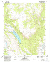
1986 Map of Bristol Head
USGS Topo · Published 1986About this map
The high-altitude drainage of the Rio Grande defines this mid-1980s topographic study of Mineral County. The central feature is the Santa Maria Reservoir, a significant water management site flanked by the prominent Long Ridge and Santa Maria Pass. The landscape is dominated by the sprawling Rio Grande National Forest, where the terrain ascends toward the volcanic massif of Bristol Head, crowned by a Radio Tower.
Find a feature on this map
36 named features on this map. Tap any name to fly to it.
Don’t see what you’re looking for? This feature index may not catch every label — zoom into the map to look around manually.
Map Details
Editions of this 1986 Bristol Head Map
This is the sole edition of this map. No revisions or reprints were ever made.
Other maps of this area

1905 · San Cristobal
USGS Topo · 1:125,000

1907 · San Cristobal
USGS Topo · 1:125,000

1914 · Creede
USGS Topo · 1:125,000

1916 · Creede
USGS Topo · 1:125,000

1945 · Durango
USGS Topo · 1:250,000

1953 · Durango
USGS Topo · 1:250,000

1954 · Durango
USGS Topo · 1:250,000

1957 · Spar City
USGS Topo · 1:62,500

1959 · Creede
USGS Topo · 1:62,500

1959 · Bristol Head
USGS Topo · 1:62,500