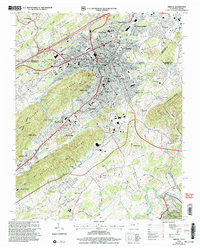
2003 Map of Bristol
USGS Topo · Published 2004About this map
Bristol straddles the state line in this early 21st-century topographic survey, where the urban centers of Tennessee and Virginia merge into a single industrial and educational hub. The map highlights the city's complex infrastructure, from the historic Union Depot and Post Office to the modern Bristol International Speedway (Dragstrip) to the south. Educational institutions like Sullins College, Virginia Intermont College, and Virginia High Sch define the central neighborhoods of Spring Garden and Virginia Heights.
Find a feature on this map
114 named features on this map. Tap any name to fly to it.
Don’t see what you’re looking for? This feature index may not catch every label — zoom into the map to look around manually.
Map Details
Editions of this 2003 Bristol Map
This is the sole edition of this map. No revisions or reprints were ever made.
Other maps of this area

1891 · Roan Mountain
USGS Topo · 1:125,000

1894 · Roan Mountain
USGS Topo · 1:125,000

1897 · Bristol
USGS Topo · 1:125,000

1902 · Bristol
USGS Topo · 1:125,000

1904 · Roan Mountain
USGS Topo · 1:125,000

1934 · Wallace
USGS Topo · 1:24,000

1934 · Holston Valley
USGS Topo · 1:24,000

1934 · Wyndale
USGS Topo · 1:24,000

1934 · Bristol
USGS Topo · 1:24,000

1935 · Watauga Valley
USGS Topo · 1:48,000