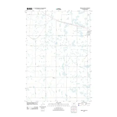
2012 Map of Bristol West
USGS Topo · Published 2012About this map
Glacial prairie potholes and scattered wetlands define this section of Day County, South Dakota, as it appeared in the early 21st century. The landscape is structured by a rigid section-line road grid, including 420th Ave and 141st St, which navigates around numerous small, unnamed water bodies. Near the center of the quadrangle, the Bethany Evangelical Cem stands as a point of historical continuity amidst the agricultural fields. To the west, the drainage of Mud Cr meanders through the terrain, while the northeastern corner shows a portion of the local township infrastructure near the Po. The prevalence of local county roads such as Cord 18 and Cord 33 illustrates the rural transportation network serving the isolated farmsteads and wetlands of the region.
Find a feature on this map
26 named features on this map. Tap any name to fly to it.
Don’t see what you’re looking for? This feature index may not catch every label — zoom into the map to look around manually.
Map Details
Editions of this 2012 Bristol West Map
This is the sole edition of this map. No revisions or reprints were ever made.
Other maps of this area

1953 · Milbank
USGS Topo · 1:250,000

1958 · Milbank
USGS Topo · 1:250,000

1958 · Andover
USGS Topo · 1:24,000

1958 · Andover SW
USGS Topo · 1:24,000

1958 · Pierpont
USGS Topo · 1:24,000
1958 · Crandall
USGS Topo · 1:24,000

1973 · Lily
USGS Topo · 1:24,000

1973 · Lynn Lake
USGS Topo · 1:24,000

1973 · Bristol West
USGS Topo · 1:24,000

1973 · Lone Tree Lake
USGS Topo · 1:24,000